Table of Contents
ToggleIntroduction
In a world dominated by digital navigation tools like Google Maps and GPS, the humble map book still holds an undeniable charm and utility. A map book serves as a collection of maps bound together in book form, often designed for specific regions or purposes, such as road navigation, hiking, or urban planning.
Whether you’re an adventurer, a student, or a professional, understanding the value of map books can open up new dimensions of navigation and geographic exploration. In this guide, we’ll dive deep into everything you need to know about map books, including their types, benefits, and modern-day relevance.
What is a Map Book?
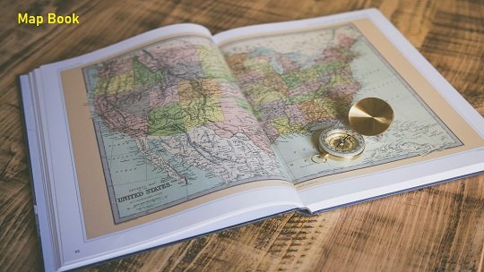
A map book is a physical or digital collection of maps, often organized systematically to cover a geographic area or thematic topic. It typically includes topographical, political, road, or custom maps designed to serve specific needs.
Key Features of a Map Book:
- Comprehensive Coverage: Detailed maps of regions, towns, or cities.
- Index and Legend: Easy navigation through an index of locations and map symbols.
- Thematic Focus: Some map books focus on specific themes like hiking trails or historical landmarks.
- Durability: High-quality map books are often printed on water-resistant or durable paper.
History of Map Books
The evolution of map books parallels the history of cartography:
- Ancient Times: The first maps were drawn on clay tablets and papyrus.
- 15th Century: Johannes Gutenberg’s invention of the printing press enabled the mass production of maps.
- 18th-19th Century: Atlases and map books became popular, particularly with the rise of imperialism and exploration.
- 20th Century: Road maps and guidebooks became household items for travelers.
Types of Map Books
Map books come in various types, each serving a unique purpose. Here’s a table outlining their differences:
| Type | Purpose | Examples |
|---|---|---|
| Road Atlas | Road navigation | Rand McNally Road Atlas, Michelin Guide |
| Topographical Map Book | Hiking and outdoor activities | USGS Topo Maps, Ordnance Survey Map Books |
| Historical Maps | Research on historical geography | Historical Atlas of the World |
| City Guides | Urban navigation and exploration | Streetwise City Maps, A-Z Map Books |
| Custom Map Books | Industry-specific or custom needs | Emergency response, utility planning maps |
Why Map Books Are Still Relevant
Despite the widespread use of GPS and mobile apps, map books remain essential for various reasons:
- Reliability Without Batteries: Map books work without the need for electricity or an internet connection.
- Detail and Scale: Often provide more detailed geographic data than digital maps.
- Educational Value: Teach navigation skills and geographic awareness.
- Customization: Tailored for specific industries like forestry, surveying, or emergency response.
Components of a Map Book
1. Cover and Title Page
- Includes the name, edition, and focus area.
- Some include a quick reference guide for readers.
2. Index
- Alphabetical listing of places for quick lookup.
3. Legend (Map Key)
- Explains the symbols, lines, and colors used in the maps.
4. Maps
- The core content, organized in logical sections, often accompanied by annotations or notes.
How to Use a Map Book Effectively
Using a map book requires basic navigation skills. Here’s a step-by-step guide:
- Identify Your Location: Use landmarks or coordinates.
- Consult the Index: Find the page for your desired location or route.
- Understand the Scale: Check the map’s scale to estimate distances.
- Follow the Legend: Decode symbols for terrain, landmarks, or other features.
Modern Map Books vs. Digital Maps
| Feature | Map Books | Digital Maps |
|---|---|---|
| Accessibility | Always accessible | Requires device and connectivity |
| Detail | Often highly detailed | Varies; can be limited in rural areas |
| Customization | Can be tailored to specific needs | Limited unless using advanced software |
| Navigation Assistance | Manual | Automated with voice commands |
| Learning Value | Encourages skill development | Relies on automation |
Industries That Still Rely on Map Books
While technology dominates, several industries still use map books:
- Emergency Services: Firefighters and paramedics use map books for precise navigation in remote areas.
- Logistics and Transportation: Truck drivers and couriers often use atlases for route planning.
- Education: Geography students and researchers reference map books for field studies.
- Outdoor Recreation: Hikers and campers rely on topographical map books.
Tips for Choosing the Right Map Book
When selecting a map book, consider the following:
- Purpose: Are you navigating roads, exploring trails, or researching history?
- Region: Ensure it covers the geographic area you need.
- Scale: Larger scales (e.g., 1:25,000) show more detail, while smaller scales (e.g., 1:250,000) cover larger areas.
- Durability: Waterproof or tear-resistant paper is ideal for outdoor use.
Customizing Your Own Map Book
For specialized needs, you can create a custom map book:
- Choose a Mapping Software: Tools like QGIS or ArcGIS are popular.
- Define the Scope: Decide on the area and themes.
- Print and Bind: Use professional printing services for durability.
Conclusion
Map books, though traditional, remain indispensable for many purposes, from education to outdoor adventures. They offer a tangible and reliable way to explore geography and navigate the world.
Whether you’re a cartography enthusiast or simply someone who values the art of maps, investing in a map book can deepen your understanding of the landscapes around you.